
Garmin Zumo Xt-Mt
KSh 62,000.00 + VAT
- Robust and weatherproof all-terrain motorcycle navigation system (IPX7 standard) with ultra-bright 5.5-inch HD touch display
- Use in portrait and landscape format as well as comfortably usable with gloves
- Street navigation maps for Europe including updates
- Pre-installed topographic maps for the site navigation in Europe
- BirdsEye satellite images via download included
- Garmin Adventurous Routing, round trip, route planning and TracBack function
- Live weather, live traffic and more via Garmin Drive app
- TripAdvisor, Foursquare, iOverlander and Garmin Motorrad POIs
- Bluetooth hands-free function, music control and integrated MP3 player
- Built-in track recorder with compass and elevation profile
- Kindly Note: Prices and Stock Status are Subject to Change without Prior Notice
- Bank Financing attracts an additional percentage
- NB: Warranty registration is the customer's responsibility
- Disclaimer. We can not guarantee that the product specs information on this page is 100% correct.
Garmin Zumo Xt-Mt in Kenya.
Garmin Zumo Xt-Mt Price in Kenya is Ksh 62,000.The zūmo XT motorcycle navigator is rugged and built for adventure. It features an ultrabright 5.5-inch display which is glove-friendly, rain-resistant and all weather resistanct and shows routes on and off the beaten path.Buy the Garmin Zumo Xt-Mt Best Price Online from CELLULAR KENYA,Nairobi
XT comes with preloaded Southern Africa Topographical map – On and Off Road.
Get exploring with routes with turn by turn directions for on road navigation and topographic or BirdsEye Satellite Imagery for off road guidance (no subscription needed). Rider alerts help prepare you for sharp curves and railroad crossings. Easily manage and review routes, tracks and waypoints across your navigator, smartphone and computer using Garmin Explore™. Pair with a compatible inReach® satellite communicator (sold separately) for interactive SOS, two way messaging and location sharing.
Rugged Build
Go confidently into every ride with a navigator that’s built to withstand all kinds of weather (IPX7) and rough rides.

Specifications:
- 5.5” ultrabright display: Glove friendly, ultrabright 5.5 inch display with crisp HD resolution can be mounted in landscape or portrait view; designed to withstand weather (IPX7) and rough terrain.
- On and off road maps: Easily switch between spoken turn by turn directions for streets in South Africa, preloaded topographic maps, and global BirdsEye Satellite Imagery, so you can always have the perfect map for your ride. Map updates included.
- Birdseye satellite imagery: Access global BirdsEye Satellite Imagery with direct to device downloads via WiFi® and no annual subscription.
- Easily manage your routes: Manage and review your routes, tracks and waypoints across your zūmo XT1, smartphone and computer using Garmin Explore™
- Sight seeing made easy: Preloaded TripAdvisor® traveller ratings, iOverlander™ points of interest, and Foursquare® content for millions of new and popular places.
- Track recorder: Records your route to save and share for future adventures.
- Works with inreach®: Pair zūmo XT with a compatible Garmin inReach Satellite Communicator (sold separately) for 2-way texting, location sharing and SOS.
- Share your favorite rides: Easily send 1 GPX files from your phone to zūmo XT.
- Garmin Adventurous routing™: Adventurous routing options find curvy and hilly routes for a more thrilling ride.
- Music player: Stream and control music from your smartphone through zūmo XT or play MP3 files stored on your zūmo XT.
- Rider safety features: Rider alerts for upcoming potential hazards such as sharp curves, Bluetooth® hands free calling and Automatic Incident Notifications which text your location to a loved one if an incident occurs.
- Live traffic, weather and more: Access live traffic and weather, share routes with other riders, and get smartphone notifications when you pair zūmo XT with your smartphone using the Garmin Drive™ app.
Related products
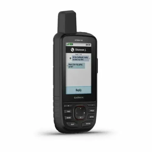
Garmin GPSMAP 66i
Key features:
- Large 3 inch Sunlight-readable color display for easy viewing
- Trigger an interactive SOS to the geos 24/7 search and rescue monitoring center, two-way messaging via the 100% Global Iridium satellite network (satellite subscription required)
- Preloaded Garmin TOPO mapping with direct-to-device Birdseye satellite imagery downloads (no annual subscription), includes multiple global navigation satellite systems (GNSS) support and navigation sensors
- Cellular connectivity lets you access active weather forecasts and geocaching live
- Compatible with the Garmin explore website and app to help you manage waypoints, routes, activities and collections, use tracks and review trip data from the field
- Internal, rechargeable lithium battery provides up to 35 hours of battery life in 10-minute tracking mode and 1-minute tracking mode (display off), 200 hours in Expedition mode with 30-minute tracking