Garmin Edge 130 Plus
KSh 29,950.00 + VAT
key features:
- Extremely lightweight and compact GPS bike computer for road and MTB with easy to read 1.8″ display even in direct sunlight or low light
- Performance evaluation and easy training plan synchronization
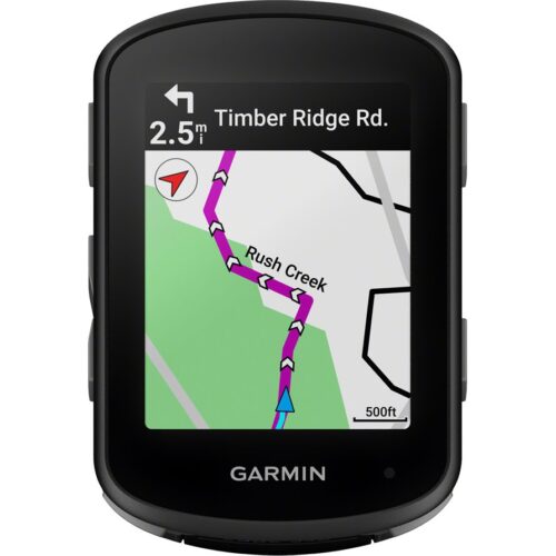
- Navigation with turn-by-turn instructions and route display
- ClimbPro for optimal planning of upcoming climbs
- MTB Dynamics with grit –, flow and jump analysis
- With GPS, GLONASS and Galileo satellites and an altimeter, you’ll know how far, fast, hard and high you’ve ridden on the longest climbs or on your way through the city
- Includes navigation with turn prompts and even shows you how to get back to start; download courses from the Course Creator feature in Garmin Connect™ online community, and race in real time against Strava Live Segments
- Compatible with Varia™ cycling awareness accessories, including rear-view radar and smart bike lights
- Connected features include smart notifications, weather and more; LiveTrack and Assistance features make it easy to share your location
- Battery life: up to 12 hours
- Kindly Note: Prices and Stock Status are Subject to Change without Prior Notice
- Bank Financing attracts an additional percentage
- NB: Warranty registration is the customer's responsibility
- Disclaimer. We can not guarantee that the product specs information on this page is 100% correct.
Garmin Edge 130 plus in Kenya.
Garmin Edge 130 plus Price in Kenya is Ksh 29,950.Buy the Garmin Edge 130 Plus Best Price Online from CELLULAR KENYA,Nairobi
Design
Extremely light and compact design (33g) with easy to read and high contrast 1.8″ display and key operation.
Performance evaluation
Improve your fitness by monitoring and analyzing your VO2max and heart rate.
Training planning
Use your indoor or outdoor training plans from Garmin Connect or synchronize training plans from providers like TrainingPeaks or TrainerRoad.
Climbpro
Before steep climbs, the ClimbPro function provides you with valuable data on gradient, distance and altitude. This allows you to optimally manage your strength.
Precise data recording
Record detailed speed, distance and position data thanks to GPS, GLONASS and GALILEO receivers and integrated altimeter.
MTB Dynamics
Grit, Flow –& Jump Analysis the new MTB Dynamics provide all the data mountain bikers need to analyze jumps and descents.
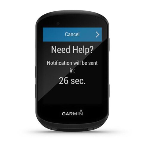
Safety features
In case of a breakdown you can transmit your location manually with the emergency call function. In the event of an accident, automatically saved emergency contacts are notified by text message and your location is shared.
Live Tracking
Launch the Live Tracking feature directly from the device so your friends can track your current position and planned route.
Smart Notications
Receive text messages and alerts on your Edge when paired with a compatible smartphone.
Any Compatible
Pair your Edge 130 Plus with a Varia radar and be warned of approaching vehicles.
Connect IQ
Enhance your Edge features with additional data fields from Connect IQ Store.
Color
- black
Weight
- 33g (manufacturer information)
Scope of delivery
- Garmin Edge® 130 Plus
- Handlebar holder
- Charging/data cable
- Operating instructions
Garmin Edge 130 Plus: Make every ride count
Related products
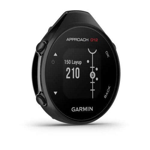
Garmin Approach G12
- Compact clip-on GPS rangefinder attaches to pocket, belt or bag
- Preloaded with over 42,000 golf courses worldwide (no subscription needed)
- Green View shows true green shape from your current position
- Drag-and-drop pin placement for precise manual green distances
- Big Numbers mode displays large, easy-to-read yardages
- Digital scorecard tracks scores on-device or via Garmin Golf app
- Automatic course detection when paired with the app
- Sunlight-readable monochrome display (176 × 176 pixels)
- Rechargeable battery lasts up to 30 hours in GPS mode
- IPX7 waterproof rating withstands rain & splashes
- Lightweight design (25.1g) for all-day comfort
- Bluetooth connectivity to Garmin Golf app for stats & tracking

Garmin Montana 710i
Key Features
-
5-inch sunlight-readable glove-friendly touchscreen
-
Multi-GNSS support (GPS, GLONASS, Galileo)
-
TOPO mapping and City Navigator routing
-
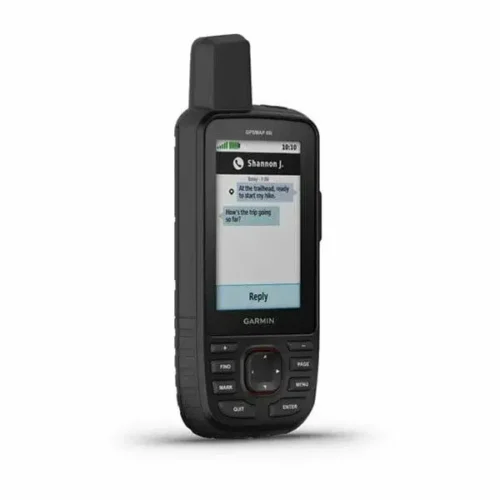
Two-way messaging and interactive SOS with inReach technology
-
Preloaded TopoActive maps
-
BirdsEye Satellite Imagery (direct download)
-
Built-in 3-axis compass and barometric altimeter
-
8-megapixel camera with geotagging
-
Wireless connectivity (Wi-Fi, Bluetooth, ANT
-
Rugged, water-resistant design (IPX7)
-
Powered by lithium-ion battery pack or AA batteries
-
Compatible with Garmin Explore app
GARMIN Edge 540 Solar
Key Features;
- Extends battery life with solar charging.
- Touchscreen interface
- Navigation, mapping, incident detection, and group tracking.
- Distance, speed, pace, elevation, heart rate, power, etc.
- Up to 26 hours in standard mode, extended with solar charging.
- Customizable display
- Works with various sensors and accessories.
- Improved map detail compared to the Edge 530.
GARMIN Edge 530GPS Bundle
- Alerts (triggers alarm when you reach time, distance, HR, calories goals): yes
- Internal memory: 16 GB
- Compatible with Varia™bike radar and lights: yes
- LiveTrack: yes
- Advanced performance and power analysis, including new Time in Zone, FTP tracking, cycling-specific VO2 and recovery and cycling dynamics
- Bike trainer profile for compatible Turbo trainer data display and control
- On-device segment compatibility for dynamic and engaging in-ride competition
- Operating temperature: -20°C to +55°C
- Connected features via a smartphone: yes
- Integration with Shimano Di2 electronic shifting: yes
- Weather alerts: yes
Garmin GPSMAP 66i
Key features:
- Large 3 inch Sunlight-readable color display for easy viewing
- Trigger an interactive SOS to the geos 24/7 search and rescue monitoring center, two-way messaging via the 100% Global Iridium satellite network (satellite subscription required)
- Preloaded Garmin TOPO mapping with direct-to-device Birdseye satellite imagery downloads (no annual subscription), includes multiple global navigation satellite systems (GNSS) support and navigation sensors
- Cellular connectivity lets you access active weather forecasts and geocaching live
- Compatible with the Garmin explore website and app to help you manage waypoints, routes, activities and collections, use tracks and review trip data from the field
- Internal, rechargeable lithium battery provides up to 35 hours of battery life in 10-minute tracking mode and 1-minute tracking mode (display off), 200 hours in Expedition mode with 30-minute tracking
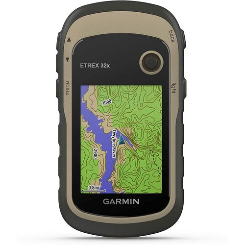
Garmin eTrex 32x GPS Navigator
Key features:
- 2.2” sunlight-readable color display with 240 x 320 display pixels for improved readability
- Preloaded with TopoActive maps with routable roads and trails for cycling and hiking
- Support for GPS and GLONASS satellite systems allows for tracking in more challenging environments than GPS alone
- 8 GB of internal memory for map downloads plus a microSD™ card slot
- eTrex 32x adds a 3-axis compass and barometric altimeter
- Battery life: up to 25 hours in GPS mode with 2 AA batteries