

Garmin GPSMAP 66i
Original price was: KSh 72,999.00.KSh 71,000.00Current price is: KSh 71,000.00. + VAT
Key features:
- Large 3 inch Sunlight-readable color display for easy viewing
- Trigger an interactive SOS to the geos 24/7 search and rescue monitoring center, two-way messaging via the 100% Global Iridium satellite network (satellite subscription required)
- Preloaded Garmin TOPO mapping with direct-to-device Birdseye satellite imagery downloads (no annual subscription), includes multiple global navigation satellite systems (GNSS) support and navigation sensors
- Cellular connectivity lets you access active weather forecasts and geocaching live
- Compatible with the Garmin explore website and app to help you manage waypoints, routes, activities and collections, use tracks and review trip data from the field
- Internal, rechargeable lithium battery provides up to 35 hours of battery life in 10-minute tracking mode and 1-minute tracking mode (display off), 200 hours in Expedition mode with 30-minute tracking
- Kindly Note: Prices and Stock Status are Subject to Change without Prior Notice
- Bank Financing attracts an additional percentage
- NB: Warranty registration is the customer's responsibility
- Disclaimer. We can not guarantee that the product specs information on this page is 100% correct.
Features and Benefits
|
|
|
|
|---|---|---|
Satellite CommunicationStaying in touch is vital, even on less challenging trips. Using inReach technology (subscription required), this handheld lets you trigger an SOS to the GEOS 24/7 emergency response team for interactive support in an emergency. It also enables two-way messaging and LiveTrack location sharing via the 100% global Iridium satellite network, so you can stay in contact with loved ones, teammates, headquarters and more. |
Weather AnywhereWireless Cellular connectivity lets you access Active Weather for up-to-date forecasts, including predictive maps for temperature, wind, precipitation and clouds — right on the handheld when connected to Garmin Connect Mobile. |
Pair with Your Mobile DeviceThe free Garmin Explore mobile app lets you plan, review and sync data, including waypoints, routes, activities and collections. Review completed activities while still in the field, even when you’re off the grid. The app also lets you sync your GPSMAP 66i with your compatible mobile device so you can access unlimited maps, aerial imagery and U.S. NOAA charts. You can even use all of the inReach features on your paired mobile device. For easier messaging, you can access your phone’s contact list from the Garmin Explore app to connect with fewer keystrokes. Plan for future trips and review previous activities from the Garmin Explore website. |


Related products
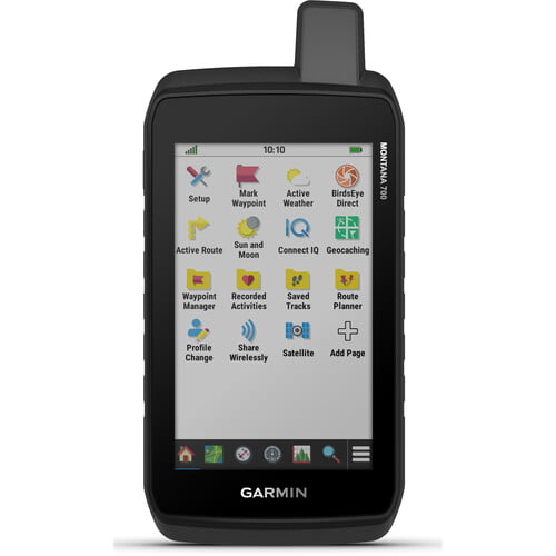
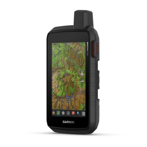
Garmin Montana 700
- Expect big things. A large touchscreen puts them all at your fingertips.
- Routable topographic maps? Check. Now you’re free to take it off-road or on.
- Built like a tank. Meets MIL-STD 810 for thermal, shock, water and vibration.
- Get the clear perspective of BirdsEye Satellite Imagery right to your device.
- Go far with no fear. ABC sensors and multiple GNSS networks have your back.
- Power your adventures with 18+ hours of lithium-ion battery life in GPS mode.
- This durable, water-resistant handheld is tested to U.S. military standards and features a glove-friendly 5” touchscreen that’s 50% larger than previous Montana models.
- To navigate your adventures, use preloaded topographical maps for the U.S. and Canada. View terrain contours, elevations, coastlines, rivers, landmarks and more.
- Optional display of federal public land boundaries on topographical maps helps you know that you’re venturing where you’re supposed to be.
- Use direct-to-device downloads of BirdsEye Satellite Imagery (no annual subscription required) to see photo-realistic views and create waypoints based on landmarks.
- Add a subscription to Outdoor Maps+, and get ongoing access to a wide variety of premium mapping content and regular updates sent right to your Garmin device via Wi-Fi® technology.
- With 16 GB of onboard memory and a microSD™ card slot for expandable storage, you can download even more maps such as City Navigator® for your drive or BlueChart® g3 for the water.
- Navigate your next trail with ABC sensors, including an altimeter for elevation data, barometer to monitor weather and 3-axis electronic compass.
- Use cellular connectivity to access up-to-date Active Weather forecasts through the Garmin Connect™ app.
- For hunters and trainers, this Montana syncs with compatible Astro® or Alpha® series handhelds (sold separately) to help track sporting dogs in the field.

Apple TV Siri Remote
Key features:
- The Siri Remote puts you in complete control of your Apple TV.
- Use Siri to find what you want to watch with just your voice
- The Touch surface lets you interact with your Apple TV quickly and easily
- Compatible with Apple TV 4k (2nd generation), Apple TV 4k (1st generation) and Apple TV HD

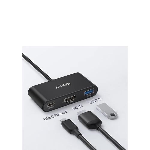
Anker Premium 5-in-1 USB-C Hub
Key features:
- Instant Expansion: Add 2 USB-A ports, 1 HDMI port, a micro SD card slot, and an SD card slot to your MacBook — all from a single USB-C port.
- Transfer Data in Seconds: Transfer and backup your files at speeds up to 5Gbps via 2 USB 3. 0 ports.
- Vivid Video: Mirror or extend your screen in a variety of resolutions including 4K@30Hz and 2K@60Hz via the HDMI port.
- SD Ready: The micro SD and SD card slots support nearly all SD card formats for quick and easy access to photos and other media — perfect for photographers and designers.
