


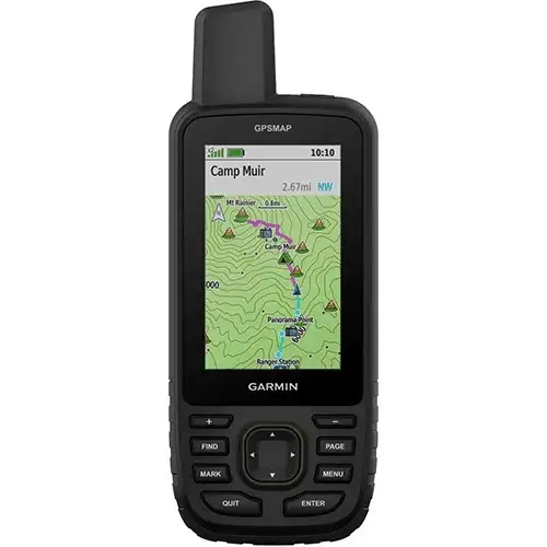
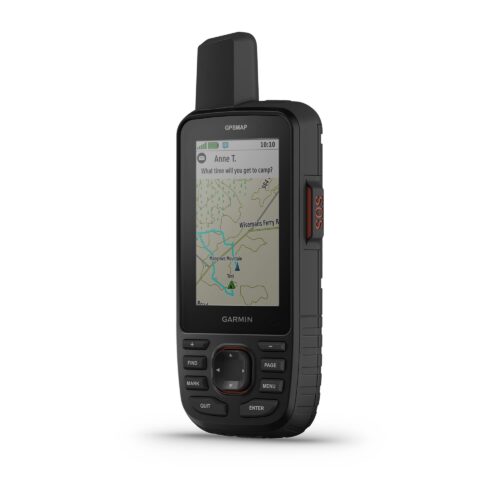
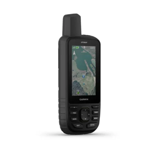
Garmin GPSMAP 65s Handheld Navigator with Altimeter, Barometer, & Compass
Original price was: KSh 58,999.00.KSh 48,999.00Current price is: KSh 48,999.00. + VAT
- Multi-Band GNSS for Optimal Accuracy
- US & Canada Routable Topo Maps
- 2.6″ Sunlight-Readable Color Display
- Barometer, Altimeter, 3-Axis Compass
- Receive Alerts from Your Phone
- Shows Public Land Boundaries
- Plan with Garmin Explore Map
- microSD Card Slot for Adding Maps
- Auto Cache Updates from Geocaching Live
- Runs on 2 x AA Batteries
- Kindly Note: Prices and Stock Status are Subject to Change without Prior Notice
- Bank Financing attracts an additional percentage
- NB: Warranty registration is the customer's responsibility
- Disclaimer. We can not guarantee that the product specs information on this page is 100% correct.
Garmin GPSMAP 65s Overview
Your outdoor adventures, whether in the backcountry or a big city, will be safer and more enjoyable with the Garmin GPSMAP 65s Handheld Navigator. This feature-rich device employs five global navigation satellite systems—GPS, GLONASS, Galileo, QZSS, and IRNSS—for pinpoint positioning, even in heavy cover, mountainous terrain, or urban canyons. The built-in altimeter, barometer, and three-axis electronic compass will aid and inform your travels. The navigator comes pre-loaded with routable topo maps of the U.S. and Canada, and has a microSD card slot for uploading finely detailed Garmin Topo 24K or HuntView Plus maps. It provides access to automatic geocaching updates from from Geocaching Live, including descriptions, logs, and hints. Emails, texts, and alerts are displayed when the GPSMAP 65 is linked with a compatible smartphone or device. You can use the device to plan, review, and sync your travels via the Garmin Explore app and website. Buy the Garmin GPSMAP 65s Handheld Navigator with Altimeter, Barometer, & Compass Best Price Online from CELLULAR KENYA,Nairobi
Related products
Garmin 67
Key Features
-
3-inch sunlight-readable color display
-
Multi-band GNSS (GPS, GLONASS, Galileo, QZSS, IRNSS)
-
Preloaded TopoActive maps
-
BirdsEye Satellite Imagery (direct download)
-
Digital 3-axis compass
-
Barometric altimeter
-
Extended battery life (up to 180 hours in standard mode, 840 hours in expedition mode)
-
Wireless connectivity (Wi-Fi®, Bluetooth®, ANT+®)
-
Rugged, water-resistant design (IPX7)
-
Garmin Explore app compatibility

GARMIN Edge 540 Solar
Key Features;
- Extends battery life with solar charging.
- Touchscreen interface
- Navigation, mapping, incident detection, and group tracking.
- Distance, speed, pace, elevation, heart rate, power, etc.
- Up to 26 hours in standard mode, extended with solar charging.
- Customizable display
- Works with various sensors and accessories.
- Improved map detail compared to the Edge 530.
Garmin Edge 130 Plus
key features:
- Extremely lightweight and compact GPS bike computer for road and MTB with easy to read 1.8″ display even in direct sunlight or low light
- Performance evaluation and easy training plan synchronization
- Navigation with turn-by-turn instructions and route display
- ClimbPro for optimal planning of upcoming climbs
- MTB Dynamics with grit –, flow and jump analysis
- With GPS, GLONASS and Galileo satellites and an altimeter, you’ll know how far, fast, hard and high you’ve ridden on the longest climbs or on your way through the city
- Includes navigation with turn prompts and even shows you how to get back to start; download courses from the Course Creator feature in Garmin Connect™ online community, and race in real time against Strava Live Segments
- Compatible with Varia™ cycling awareness accessories, including rear-view radar and smart bike lights
- Connected features include smart notifications, weather and more; LiveTrack and Assistance features make it easy to share your location
- Battery life: up to 12 hours
Garmin GPSMAP 66i
Key features:
- Large 3 inch Sunlight-readable color display for easy viewing
- Trigger an interactive SOS to the geos 24/7 search and rescue monitoring center, two-way messaging via the 100% Global Iridium satellite network (satellite subscription required)
- Preloaded Garmin TOPO mapping with direct-to-device Birdseye satellite imagery downloads (no annual subscription), includes multiple global navigation satellite systems (GNSS) support and navigation sensors
- Cellular connectivity lets you access active weather forecasts and geocaching live
- Compatible with the Garmin explore website and app to help you manage waypoints, routes, activities and collections, use tracks and review trip data from the field
- Internal, rechargeable lithium battery provides up to 35 hours of battery life in 10-minute tracking mode and 1-minute tracking mode (display off), 200 hours in Expedition mode with 30-minute tracking