


Garmin eTrex 32x GPS Navigator
Original price was: KSh 28,999.00.KSh 25,999.00Current price is: KSh 25,999.00. + VAT
Key features:
- 2.2” sunlight-readable color display with 240 x 320 display pixels for improved readability
- Preloaded with TopoActive maps with routable roads and trails for cycling and hiking
- Support for GPS and GLONASS satellite systems allows for tracking in more challenging environments than GPS alone
- 8 GB of internal memory for map downloads plus a microSD™ card slot
- eTrex 32x adds a 3-axis compass and barometric altimeter
- Battery life: up to 25 hours in GPS mode with 2 AA batteries
- Kindly Note: Prices and Stock Status are Subject to Change without Prior Notice
- Bank Financing attracts an additional percentage
- NB: Warranty registration is the customer's responsibility
- Disclaimer. We can not guarantee that the product specs information on this page is 100% correct.
Garmin ETREX 32X Price in Kenya
The Garmin ETREX 32X Price in Kenya 25999. The eTrex 22x and 32x handheld devices come preloaded with road-routable TopoActive maps that feature streets and trails so you can take the journey off the grid. Now you can know your surroundings — such as waterways, natural features as well as buildings, international boundaries and more. You can also find thousands of points of interests, including shops, restaurants, universities, car parks and accommodations.
Explore Confidently with the Reliable Handheld GPS
- 2.2” sunlight-readable color display with 240 x 320 display pixels for improved readability
- Preloaded with TopoActive maps with routable roads and trails for cycling and hiking
- Support for GPS and GLONASS satellite systems allows for tracking in more challenging environments than GPS alone
- 8 GB of internal memory for map downloads plus a microSD™ card slot
- eTrex 32x adds a 3-axis compass and barometric altimeter
- Battery life: up to 25 hours in GPS mode with 2 AA batteries
eTrex 22x and eTrex 32x offer the same ease-of-use, durability and affordability that the eTrex handheld GPS series is known for — along with preloaded TopoActive maps. These devices are perfect for ATVs, bicycles, boats or hiking.
See the Way
eTrex 22x and 32x offer enhanced 2.2”, 65K color, sunlight-readable displays. Durable and water resistant, these handhelds are built to withstand the elements.
Keep Your Fix
The eTrex series uses both GPS and GLONASS satellite systems so the receiver has the ability to track in more challenging environments than GPS alone. eTrex 32x adds a 3-axis compass and barometric altimeter, making it easy for you to keep your bearings.
Add Maps
With a microSD card slot and expanded 8 GB of internal memory, you can easily download additional maps for wherever the adventure takes you.
Satellite Imagery
Both devices support BirdsEye Satellite Imagery (subscription required), so you can download and integrate satellite imagery with your maps.
Find Fun
eTrex 22x and eTrex 32x support paperless geocaching. Upload GPX files straight to your device, and view key information such as location, terrain and hints from Geocaching.com
Go Anywhere
With an array of compatible mounts, eTrex is designed as a handheld — for use on ATVs or bicycles, in boats or on foot. Use the auto mount capability and City Navigator® NT maps for turn-by-turn driving directions, or use the rugged mount for your motorcycle or ATV. Wherever you think you might take eTrex, it has the mapping and mounts to get you there.
Buy The Garmin eTrex 32x GPS Navigator Best Price Online from CELLULAR KENYA,Nairobi
Related products

Garmin Edge 130 Plus
- Extremely lightweight and compact GPS bike computer for road and MTB with easy to read 1.8″ display even in direct sunlight or low light
- Performance evaluation and easy training plan synchronization
- Navigation with turn-by-turn instructions and route display
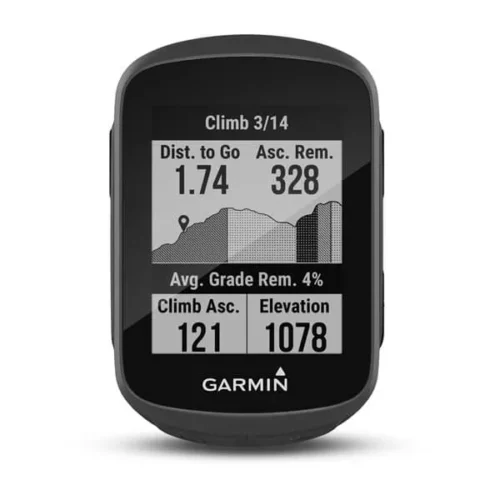
- ClimbPro for optimal planning of upcoming climbs
- MTB Dynamics with grit –, flow and jump analysis
- With GPS, GLONASS and Galileo satellites and an altimeter, you’ll know how far, fast, hard and high you’ve ridden on the longest climbs or on your way through the city
- Includes navigation with turn prompts and even shows you how to get back to start; download courses from the Course Creator feature in Garmin Connect™ online community, and race in real time against Strava Live Segments
- Compatible with Varia™ cycling awareness accessories, including rear-view radar and smart bike lights
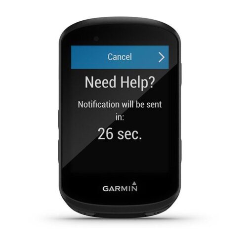
- Connected features include smart notifications, weather and more; LiveTrack and Assistance features make it easy to share your location
- Battery life: up to 12 hours
GARMIN Edge 530GPS Bundle
- Alerts (triggers alarm when you reach time, distance, HR, calories goals): yes
- Internal memory: 16 GB
- Compatible with Varia™bike radar and lights: yes
- LiveTrack: yes
- Advanced performance and power analysis, including new Time in Zone, FTP tracking, cycling-specific VO2 and recovery and cycling dynamics
- Bike trainer profile for compatible Turbo trainer data display and control
- On-device segment compatibility for dynamic and engaging in-ride competition
- Operating temperature: -20°C to +55°C
- Connected features via a smartphone: yes
- Integration with Shimano Di2 electronic shifting: yes
- Weather alerts: yes

Apple TV Siri Remote
- The Siri Remote puts you in complete control of your Apple TV.
- Use Siri to find what you want to watch with just your voice
- The Touch surface lets you interact with your Apple TV quickly and easily
- Compatible with Apple TV 4k (2nd generation), Apple TV 4k (1st generation) and Apple TV HD
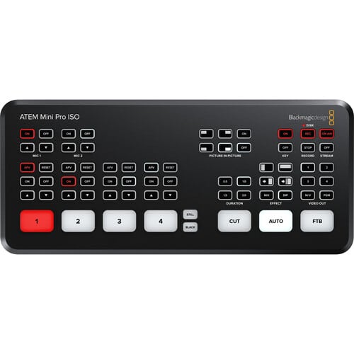
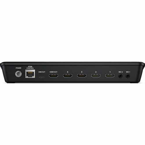
Blackmagic Design ATEM Mini Pro ISO HDMI Live Stream Switcher
- 4-Channel Live Stream HDMI Switcher
- Program and 4 x Input ISO Recording
- Generates DaVinci Resolve Project
- Live Tally, Stream, and Record Status
- Record Button, Channel Preview Multiview
- 2-Channel Digital Audio Mixer per Source
- HDMI Output, Ethernet ATEM Control
- Media Player, Computer Input Support
- Upstream and Downstream Keyers
- DVE Transition, Chroma/Luma Keyers