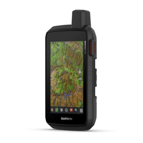
Garmin Gpsmap 67i
Original price was: KSh 88,000.00.KSh 79,999.00Current price is: KSh 79,999.00. + VAT
- Kindly Note: Prices and Stock Status are Subject to Change without Prior Notice
- Bank Financing attracts an additional percentage
- NB: Warranty registration is the customer's responsibility
- Disclaimer. We can not guarantee that the product specs information on this page is 100% correct.
Garmin Gpsmap 67i In Kenya
Garmin Gpsmap 67i Price in Kenya is Ksh 79999.GO EXPLORE THE OUTDOORS – AND STAY CONNECTED TO HOME
Make more time for adventure with this premium, rugged handheld GPS and satellite communicator. Get inReach® technology that enables two-way messaging, interactive SOS alerts and location sharing1 plus mapping to keep you on course.Buy the Garmin Gpsmap 67i Best Price Online from CELLULAR KENYA,Nairobi
-Travel longer with up to 165 hours of battery life in tracking mode and up to 425 hours in expedition mode.
-Two-way messaging lets you share the moment with the ones who matter.
-Let your loved ones follow your adventure with location tracking.
-Have an emergency? Trigger an interactive SOS alert anytime, globally.
-Track your position in challenging conditions with multi-band technology and expanded GNSS support.
N.B. InReach subscription is required for Satellite messaging & SOS function, please see our FAQ’s tab.
Related products
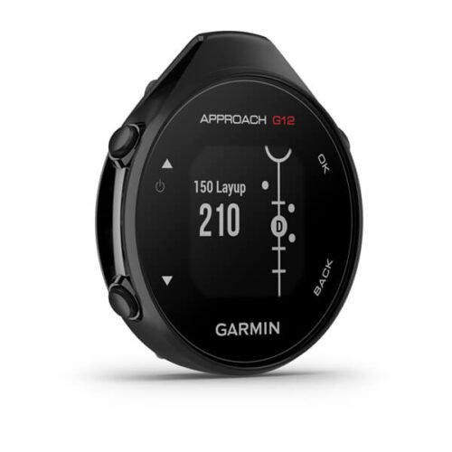
Garmin Approach G12
- Compact clip-on GPS rangefinder attaches to pocket, belt or bag
- Preloaded with over 42,000 golf courses worldwide (no subscription needed)
- Green View shows true green shape from your current position
- Drag-and-drop pin placement for precise manual green distances
- Big Numbers mode displays large, easy-to-read yardages
- Digital scorecard tracks scores on-device or via Garmin Golf app
- Automatic course detection when paired with the app
- Sunlight-readable monochrome display (176 × 176 pixels)
- Rechargeable battery lasts up to 30 hours in GPS mode
- IPX7 waterproof rating withstands rain & splashes
- Lightweight design (25.1g) for all-day comfort
- Bluetooth connectivity to Garmin Golf app for stats & tracking

GARMIN Edge 540 Solar
Key Features;
- Extends battery life with solar charging.
- Touchscreen interface
- Navigation, mapping, incident detection, and group tracking.
- Distance, speed, pace, elevation, heart rate, power, etc.
- Up to 26 hours in standard mode, extended with solar charging.
- Customizable display
- Works with various sensors and accessories.
- Improved map detail compared to the Edge 530.
Garmin Edge 1040
Key features:
- Advanced GPS bike computer combines superior navigation, planning and performance tracking, cycling awareness and smart connectivity
- Find your way in the most challenging environments with multi-band GNSS technology that provides enhanced positioning accuracy
- Simplified setup and a streamlined interface make it quick and easy to access the information, courses and tools you need and even adjust data fields right from the Edge device or from your paired smartphone
- Classify your strengths as a cyclist, and compare your cycling ability to the demands of a specific course when paired with your compatible sensors, so you can focus your training and improvement in the right areas
- Manage your efforts with the power guide feature, which recommends power targets throughout a course, when paired with your compatible sensors
- Get stamina feature insights while you ride, when paired with your compatible sensors, so you can keep an eye on how much longer you can really push it
- Stay on top of your training program with prompts to complete missed workouts