Garmin Edge 1040
KSh 87,999.00 + VAT
Key features:
- Advanced GPS bike computer combines superior navigation, planning and performance tracking, cycling awareness and smart connectivity
- Find your way in the most challenging environments with multi-band GNSS technology that provides enhanced positioning accuracy
- Simplified setup and a streamlined interface make it quick and easy to access the information, courses and tools you need and even adjust data fields right from the Edge device or from your paired smartphone
- Classify your strengths as a cyclist, and compare your cycling ability to the demands of a specific course when paired with your compatible sensors, so you can focus your training and improvement in the right areas
- Manage your efforts with the power guide feature, which recommends power targets throughout a course, when paired with your compatible sensors
- Get stamina feature insights while you ride, when paired with your compatible sensors, so you can keep an eye on how much longer you can really push it
- Stay on top of your training program with prompts to complete missed workouts
- Kindly Note: Prices and Stock Status are Subject to Change without Prior Notice
- Bank Financing attracts an additional percentage
- NB: Warranty registration is the customer's responsibility
- Disclaimer. We can not guarantee that the product specs information on this page is 100% correct.
Related products

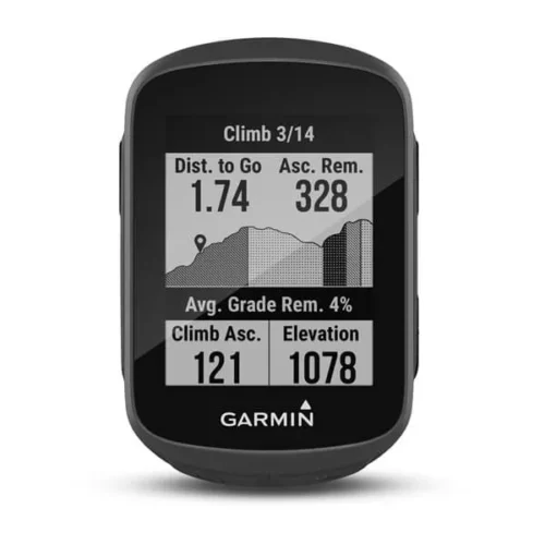
Garmin Edge 130 Plus
key features:
- Extremely lightweight and compact GPS bike computer for road and MTB with easy to read 1.8″ display even in direct sunlight or low light
- Performance evaluation and easy training plan synchronization
- Navigation with turn-by-turn instructions and route display
- ClimbPro for optimal planning of upcoming climbs
- MTB Dynamics with grit –, flow and jump analysis
- With GPS, GLONASS and Galileo satellites and an altimeter, you’ll know how far, fast, hard and high you’ve ridden on the longest climbs or on your way through the city
- Includes navigation with turn prompts and even shows you how to get back to start; download courses from the Course Creator feature in Garmin Connect™ online community, and race in real time against Strava Live Segments
- Compatible with Varia™ cycling awareness accessories, including rear-view radar and smart bike lights
- Connected features include smart notifications, weather and more; LiveTrack and Assistance features make it easy to share your location
- Battery life: up to 12 hours
-17%
GARMIN Edge 530GPS Bundle
- Alerts (triggers alarm when you reach time, distance, HR, calories goals): yes
- Internal memory: 16 GB
- Compatible with Varia™bike radar and lights: yes
- LiveTrack: yes
- Advanced performance and power analysis, including new Time in Zone, FTP tracking, cycling-specific VO2 and recovery and cycling dynamics
- Bike trainer profile for compatible Turbo trainer data display and control
- On-device segment compatibility for dynamic and engaging in-ride competition
- Operating temperature: -20°C to +55°C
- Connected features via a smartphone: yes
- Integration with Shimano Di2 electronic shifting: yes
- Weather alerts: yes